Emerita Announces Results of Airborne Electromagnetic and Magnetic Survey, Provides Update on Mineral Resources Estimate
View PDF version of this release:
ENGLISH
TORONTO, April 07, 2026 (GLOBE NEWSWIRE) -- Emerita Resources Corp. (TSX-V: EMO; OTCQX: EMOTF; FSE: LLJA) (the “Company” or “Emerita”) has received the interpreted results from Helicopter time-domain electromagnetic and magnetic (HTEM) airborne geophysical surveying completed in December (see the Company’s news release dated December 1, 2025). The survey covered 13,900 hectares over its mineral claims in the Iberian Belt West Project (“IBW” or the “Project”) area (Figure 1), covering the IBW property and the large adjacent San Antonio land package.
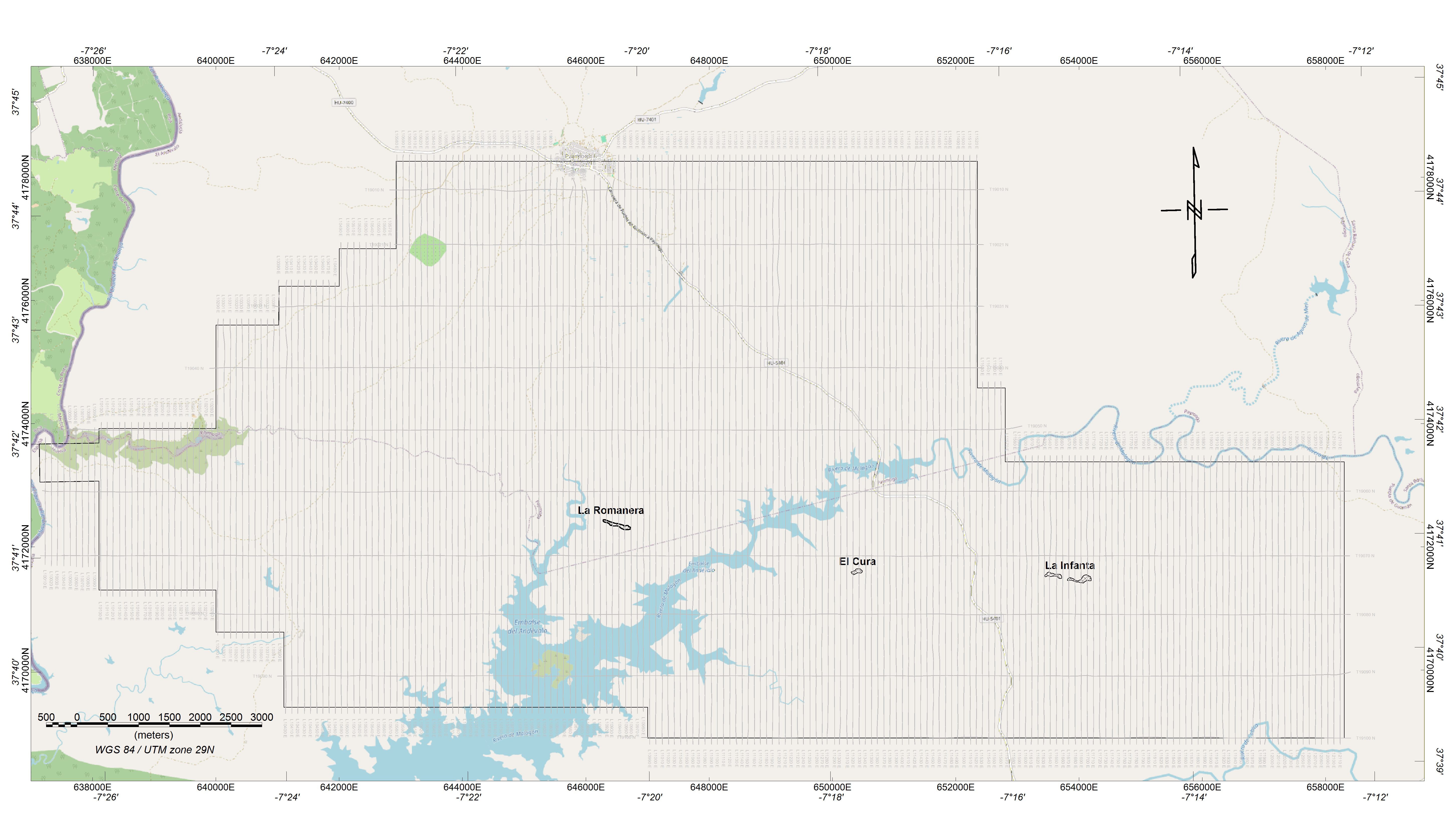
Figure 1: HTEM survey outline showing geographical features of the area; north-south survey flight lines and east-west tie-lines. The Company’s IBW Project deposits of Romanera, El Cura and La Infanta shown in black.
View Figure 1 here: https://www.globenewswire.com/NewsRoom/AttachmentNg/4358615c-eede-42fe-b564-ae8ec2de78d2
Discussion
The airborne HTEM survey covered Emerita’s combined landholdings of IBW, Infanta Sur and San Antonio, plus the tenements of Tamujoso, Sampedro, Sonia, Secundino and Rocio, that are under application by the Company, awaiting final awarding by the mines department. From a geological perspective, the area is characterized by two distinct domains (Figure 2): a domain in the northern half characterized by a thin (0-200 meters estimated in the survey area) blanket of younger cover rocks (Blanket Rock Domain), and a southern half where volcano-sedimentary rocks that are host rocks for the mineral deposits in the area (Host Rock Domain).
Host Rock Domain
The block includes numerous historic mines and prospects as well as exposed portions of the northwestern Spanish Iberian Pyrite Belt (Figure 2). The brightly colored volcano-sedimentary host rocks displayed on the map contain over 30 historic mines and prospects, as indicated by the black symbols.
Geophysical interpretation has identified several targets in this area. These targets coincide with some of the historical mineral deposits located within the exposed volcano-sedimentary units, one of which is the La Romanera deposit. The Company is conducting detailed mapping and structural interpretation of the identified geophysical targets to prioritize them for planned drilling.
Blanket Rock Domain
A significant portion of the area, particularly the northern part of the survey area, is blanketed by younger sedimentary cover that overlies the prospective Pyrite Belt formations (Figure 2). The cover in this area is interpreted to be relatively thin (up to 200 meters thick) as evidenced by windows of the Pyrite Belt stratigraphy that are exposed within the covered area. There are several known copper occurrences in these windows suggesting very good prospectivity in this area. Deep-seeking geophysical investigation through younger cover rocks is a prime technique, coupled with gravity surveys, that has resulted in many of the most significant discoveries of the area in the last 50 years, including Neves Corvo, Cobre Las Cruces, Masa Valverde, Magdelena and Lagoa Salgada deposits.
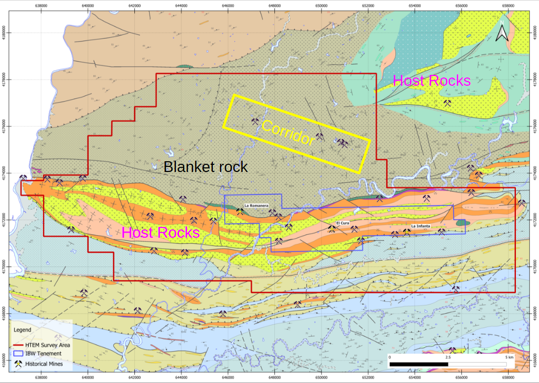
Figure 2: Geological map showing brightly colored volcano-sedimentary host rocks that contain numerous historic mines and prospects; dark brown Blanket Rocks that cover inferred volcano-sedimentary host rocks to the north of the IBW Project (blue outline, with La Romanera, El Cura and La Infanta deposits); and prospective corridor identified by recent geophysical survey, surface prospecting and geological interpretation.
View Figure 2 here: https://www.globenewswire.com/NewsRoom/AttachmentNg/0a283dc5-630b-4481-a6f4-e3a9b00c62be
The survey captured electromagnetic, magnetic and topographic data that help the Company’s geologists interpret the rock types and geological structures below (Figure 3).
In contrast, to the north of IBW in the area covered by the Blanket Rocks there are far fewer identified prospects. The several known deposits are found in restricted windows of exposure, where erosional processes have revealed the host rocks below. These mineralized exposures confirm that the covered area to the north of the IBW Project hosts a continuation of the Iberian Pyrite Belt host rocks, concealed by younger formations.

Figure 3: Oblique view looking north of the aerial survey resistivity-conductivity results. Top panel shows low-resistivity of Blanket Rocks at surface (cool colors) with high-resistivity Host Rocks (hot colors). Bottom panel reveals interpreted Host Rocks below the Blanket Rocks, interpreted slice at 330m below surface. Prospective corridor of Figure 1 shown as yellow rectangle.
View Figure 3 here: https://www.globenewswire.com/NewsRoom/AttachmentNg/e3d7af14-f25a-4eee-ac36-fcbcb2c867a6
According to Joaquin Merino, P.Geo., President of Emerita, “The survey has identified areas under the sedimentary cover with similar signatures as the rocks at surface that host known deposits. The Company’s geologists will now use their knowledge of the surface geology and the geophysical responses of the known deposits to infer similar relationships along prospective corridors at depth. There appears to be a structural corridor that hosts several windows of prospective stratigraphy and mineralized occurrences that is at least 5 km long (Figure 3).”
Surface mapping along one such corridor identified in the survey has shown both primary copper sulphide minerals as well as secondary copper minerals possibly related to a yet to be identified massive sulphide body in the vicinity (Figure 4).
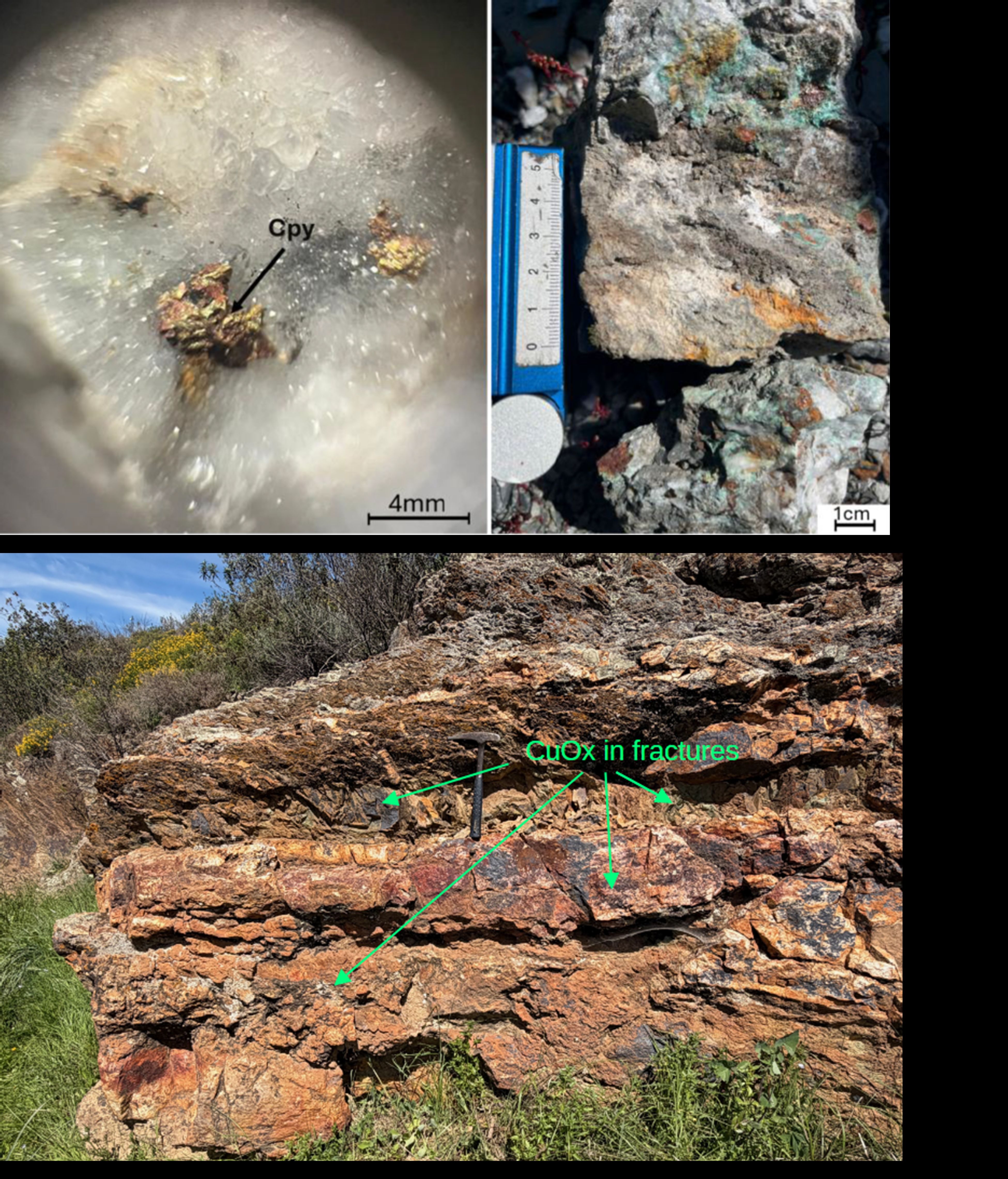
Figure 4: Copper mineralization collected at surface along recently identified “prospective corridor” at San Antonio.
View Figure 4 here: https://www.globenewswire.com/NewsRoom/AttachmentNg/036cb7d6-b78f-49b9-8db0-6e2a04337c4f
Follow-up ground-based geophysical programs are currently being designed to further refine the targets from the airborne survey and prioritize locations for drilling later in the year in both the Blanket Rock and Host Rock areas.
Program Details and Strategy
Helicopter-mounted sensors recorded a detailed elevation profile of the ground below, while simultaneously measuring electrical and magnetic properties of the rocks up to approximately 500m depth below surface. Flight lines were spaced at 100m separation and controlled by a differential GPS navigational system. Xcalibur Smart Mapping, a leading global supplier of aerial geophysical surveys, was selected through a competitive bidding process conducted in September and October 2025. Program QA/QC and the interpretation of results were conducted by Intelligent Exploration of Canada.
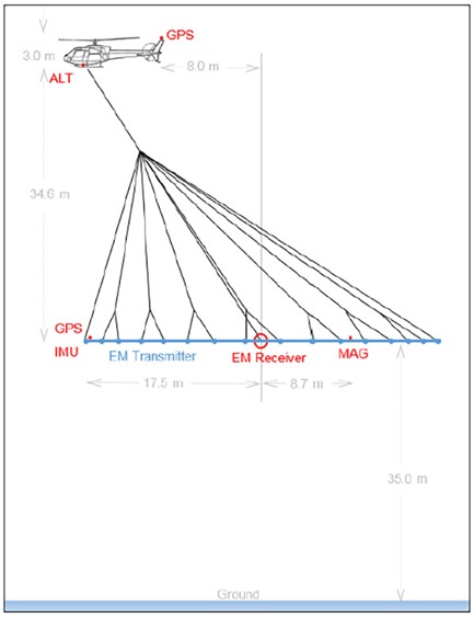
Figure 5: Diagram of helicopter-borne electromagnetic survey system, courtesy Xcalibur Smart Mapping.
View Figure 5 here: https://www.globenewswire.com/NewsRoom/AttachmentNg/d6461ada-e5f3-4f1f-8041-2363f59dd020
2026 Mineral Resource Estimate
The Company is currently reviewing input parameters for the updated NI 43-101 Mineral Resource Estimate (“MRE”) with its consultants, SLR Consulting Limited. A key change to the methodology adopted for the 2026 MRE update is that rather than resource blocks based on Metal Equivalents as was used in the 2025 MRE (see press release dated March 17, 2025), the updated 2026 MRE will adopt resource blocks based on the Net Smelter Return (“NSR”). NSR calculations are based on inputs such as metal pricing, payables, mining costs, and metallurgical processing costs. NSR values are considered a more accurate standard of reporting resources, particularly for polymetallic deposits such as at the IBW project. Significant work to accurately establish the operating costs to be used in the NSR calculation for MRE had to be completed which has delayed the release of the new MRE. Emerita is currently evaluating trade-offs of the NSR inputs to maximize the NSR value. The Company regrets delaying the updated MRE announcement as it finalizes these parameters and expects that an updated MRE will be announced in the near future.
Qualified Person
Scientific and technical information in this news release has been reviewed and approved by Joaquin Merino, P.Geo., who is a “Qualified Person” as defined by National Instrument 43-101 – Standards of Disclosure for Mineral Projects (“NI 43-101”) and President of the Company. Mr. Merino is not independent of the Company.
About Emerita Resources Corp.
Emerita is a natural resource company engaged in the acquisition, exploration, and development of mineral properties in Europe, with a primary focus on exploring in Spain. The Company’s corporate office and technical team are based in Sevilla, Spain with an administrative office in Toronto, Canada
For further information, contact:
Ian Parkinson
+1 647 910-2500 (Toronto)
info@emeritaresources.com
www.emeritaresources.com
Cautionary Note Regarding Forward-looking Information
This press release contains “forward-looking information” within the meaning of applicable Canadian securities legislation. Forward-looking information includes, without limitation, statements regarding the prospectivity of the IBW project, the mineralization and the IBW project, the economic viability of the IBW project, the timing and results of the MRE, the NSR calculation and inputs thereof, the Company’s exploration program, the Company’s future exploration plans and the Company’s future plans. Generally, forward-looking information can be identified by the use of forward-looking terminology such as “plans”, “expects” or “does not expect”, “is expected”, “budget”, “scheduled”, “estimates”, “forecasts”, “intends”, “anticipates” or “does not anticipate”, or “believes”, or variations of such words and phrases or state that certain actions, events or results “may”, “could”, “would”, “might” or “will be taken”, “occur” or “be achieved”. Forward-looking information is subject to known and unknown risks, uncertainties and other factors that may cause the actual results, level of activity, performance or achievements of Emerita, as the case may be, to be materially different from those expressed or implied by such forward-looking information, including but not limited to: general business, economic, competitive, geopolitical and social uncertainties; the actual results of current exploration activities; risks associated with operation in foreign jurisdictions; ability to successfully integrate the purchased properties; foreign operations risks; and other risks inherent in the mining industry. Although Emerita has attempted to identify important factors that could cause actual results to differ materially from those contained in forward-looking information, there may be other factors that cause results not to be as anticipated, estimated or intended. There can be no assurance that such information will prove to be accurate, as actual results and future events could differ materially from those anticipated in such statements. Accordingly, readers should not place undue reliance on forward-looking information. Emerita does not undertake to update any forward-looking information, except in accordance with applicable securities laws.
NEITHER TSX VENTURE EXCHANGE NOR ITS REGULATION SERVICES PROVIDER (AS THAT TERM IS DEFINED IN THE POLICIES OF THE TSX VENTURE EXCHANGE) ACCEPTS RESPONSIBILITY FOR THE ADEQUACY OR ACCURACY OF THIS RELEASE